Introduction of the Summer Penn 2024
We wish to advise our rate payers that due to the unprecedented wet conditions this year and the impact on ground conditions we intend to delay putting in the summer penn (normally 1st April) to allow the situation to improve. We appreciate that this may cause some localised inconvenience where landowners/occupiers are expecting summer penn to be in place to provide wet fencing and drinking water for stock, so we will do our best to be flexible and try and accommodate reasonable requests where possible.
Please click on link below to view EA water situation report February 2024:
We will continue to monitor the situation and the summer penn will be introduced as soon as reasonably possible.
Please contact the main office if you wish to discuss the summer penning arrangements within your area.
Water Levels
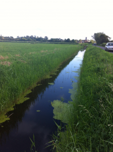
The Boards maintained network of watercourses (Viewed Rhynes) are the primary routes  by which water is removed from the land and field ditches to the Main Rivers (Environment Agency) in Somerset. In addition, they may also be the primary routes by which a supply of water is brought to field ditches (Riparian owned) from the main rivers in summer. In many situations the direction of the flow of water in the rhyne or watercourse system may be different in summer to winter.
The Boards’ network of watercourses are grouped into catchments or districts to provide hydrological and operational areas. These catchments or districts are operated by a combination of Board expenditors, members or local landowners under the supervision of a Consortium Engineer or Supervisor.
The water levels held in the Board’s rhyne systems and the main rivers are controlled by an extensive system of sluices, structures and pumping stations. All of the principle structures and pumping stations are owned and operated by the Environment Agency. The Boards are therefore heavily dependant on the timely operation and maintenance of the Agency’s structures. The Boards themselves operate and maintain an extensive network of minor water control structures that ensure the drainage and irrigation of Local Watercourses meets the needs of that particular land management.
In many catchments Water Level Management Plans (WLMPs) have been set up and agreed by a number of the bodies or authorities interested in the water level management in an area. Drainage Boards operate most of these plans although the Environment Agency also operate a number. These plans seek to achieve a consensus approach to water levels that are needed in an area across all the different interest groups that exist. Drainage Boards with their local accountability are clearly the relevant body to undertake this role. You can visit our WLMP page for more information on a plan that may be in place in your local area.
Different types of Watercourses
Watercourse
A watercourse is defined in the Land Drainage Act 1991 as:
Watercourse includes all rivers and streams and all ditches drains, cuts, culverts, dikes, sewers other than public sewers within the meaning of the Water Industry Act 1991 and passages , through which water flows.
Land Drainage Act 1991
The Act does not state that water must flow through the watercourse at all times to be a watercourse.
Main Rivers
Main Rivers are normally the principle or arterial watercourses in an area and are designated as such on maps held by the Department for Environment, Food and Rural Affairs (Defra) and the Environment Agency. The term also includes any structures in the bed or bank for controlling or regulating the flow of these watercourses. The Environment Agency has permissive (not mandatory) powers to carry out maintenance and improvement works on Main Rivers.
Any works in or near Main Rivers require the consent of the Environment Agency under either their Byelaws or Section 109 of the Water Resources Act 1991. The Board will be happy to advise you if this applies to a watercourse adjacent to your land.
Ordinary Watercourses
The term Ordinary Watercourse describes all the remaining watercourses that are not Main Rivers. These may include all tributaries, streams, rhynes, ditches and those watercourses that have been culverted or piped. The Board and County Councils have certain regulatory powers to control activities on all Ordinary Watercourses. Under Section 23 of the Land Drainage Act 1991, any proposals to construct or alter any mill dam, weir or similar obstruction to flow require consent from the Board. The erection of, or alteration to, a culvert likely to affect the flow also requires consent from the Board. For more information see Land Drainage Consents.
The Board has Land Drainage Byelaws, which require persons to obtain the Board’s consent for activities within 9 metres of an ordinary watercourse. Such activities include the erection of fences, the construction of bridges or culverts, the placing of pipes or cables over or under viewed rhynes, tree planting, disposal of rubbish, excavation affecting the bed and banks of viewed rhynes, the erection of jetties or walls, etc. See the Byelaws page for more information and downloadable copies of the Byelaws. Depending on the size and location of an Ordinary Watercourse the Board may waive its right to consent the works if the impacts of the proposals are insignificant.
The Board has permissive (not mandatory) powers to carry out maintenance and improvement works on Ordinary Watercourses, however work is normally restricted to the Viewed Rhyne network.
Viewed Rhynes
Viewed Rhynes are Ordinary Watercourses (both open or culverted) that undertake a significant function in the drainage or irrigation of an area. Viewed Rhynes are maintained by the Board on a regular or infrequent basis. The Board undertakes its consenting and enforcement powers on all rhynes. The Board designates watercourses as Viewed Rhynes by Board resolution. Maps showing Viewed Rhynes can be inspected at the Consortium office in Highbridge. The term also includes any structures in the bed or banks for controlling or regulating the flow of these watercourses. The Board has permissive (not mandatory) powers to carry out maintenance and improvement works on Viewed Rhynes.


